| Property |
Value |
| dbo:abstract
|
- La commanderie de Garway est une commune dans le Sud-Ouest du comté d’Herefordshire (Midlands de l'Ouest), Angleterre. Elle est située à flanc de coteau au-dessus du fleuve Monnow, à environ 10 kilomètres au nord-ouest de Monmouth. (fr)
- La commanderie de Garway est une commune dans le Sud-Ouest du comté d’Herefordshire (Midlands de l'Ouest), Angleterre. Elle est située à flanc de coteau au-dessus du fleuve Monnow, à environ 10 kilomètres au nord-ouest de Monmouth. (fr)
|
| dbo:country
| |
| dbo:thumbnail
| |
| dbo:wikiPageExternalLink
| |
| dbo:wikiPageID
| |
| dbo:wikiPageLength
|
- 5844 (xsd:nonNegativeInteger)
|
| dbo:wikiPageRevisionID
| |
| dbo:wikiPageWikiLink
| |
| prop-fr:année
|
- 2004 (xsd:integer)
- 2007 (xsd:integer)
- 2011 (xsd:integer)
|
| prop-fr:fondation
| |
| prop-fr:fr
|
- Manoir de Dinmore (fr)
- église de Garway (fr)
- Manoir de Dinmore (fr)
- église de Garway (fr)
|
| prop-fr:géolocalisation
|
- Angleterre (fr)
- Angleterre (fr)
|
| prop-fr:id
|
- Nicholson2013 (fr)
- Nicholson2013 (fr)
|
| prop-fr:isbn
| |
| prop-fr:lang
| |
| prop-fr:langue
| |
| prop-fr:nom
|
- Lord (fr)
- Nicholson (fr)
- Ralls (fr)
- Lord (fr)
- Nicholson (fr)
- Ralls (fr)
|
| prop-fr:nommonument
|
- Commanderie de Garway (fr)
- Commanderie de Garway (fr)
|
| prop-fr:pagesTotales
|
- 301 (xsd:integer)
- 348 (xsd:integer)
- 653 (xsd:integer)
|
| prop-fr:passage
|
- 21 (xsd:integer)
- 96 (xsd:integer)
- 202 (xsd:integer)
- 323 (xsd:integer)
|
| prop-fr:pays
|
- Angleterre (fr)
- Angleterre (fr)
|
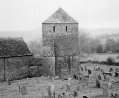
| prop-fr:photo
|
- St Michael, Garway, Herefordshire - geograph.org.uk - 346127.jpg (fr)
- St Michael, Garway, Herefordshire - geograph.org.uk - 346127.jpg (fr)
|
| prop-fr:prénom
|
- Evelyn (fr)
- Karen (fr)
- Helen J. (fr)
- Evelyn (fr)
- Karen (fr)
- Helen J. (fr)
|
| prop-fr:reprise
| |
| prop-fr:région
|
- Herefordshire (fr)
- Herefordshire (fr)
|
| prop-fr:sousTitre
|
- Garway and South Wales (fr)
- The Essential Guide to the People, Places, Events, and Symbols of the Order of the Temple (fr)
- the Translation (fr)
- Garway and South Wales (fr)
- The Essential Guide to the People, Places, Events, and Symbols of the Order of the Temple (fr)
- the Translation (fr)
|
| prop-fr:texte
|
- Dinmore (fr)
- église de Garway (fr)
- Dinmore (fr)
- église de Garway (fr)
|
| prop-fr:titre
|
- The Knights Templar in Britain (fr)
- Knights Templar Encyclopedia (fr)
- The proceedings against the templars in the british Isles (fr)
- The Knights Templar in Britain (fr)
- Knights Templar Encyclopedia (fr)
- The proceedings against the templars in the british Isles (fr)
|
| prop-fr:titreChapitre
|
- The Templars in Britain (fr)
- The Templars in Britain (fr)
|
| prop-fr:trad
|
- Dinmore Manor (fr)
- Garway#Garway church (fr)
- Dinmore Manor (fr)
- Garway#Garway church (fr)
|
| prop-fr:volume
| |
| prop-fr:wikiPageUsesTemplate
| |
| prop-fr:éditeur
|
- Pearson Education (fr)
- Ashgate Publishing (fr)
- Career Press (fr)
- Pearson Education (fr)
- Ashgate Publishing (fr)
- Career Press (fr)
|
| dct:subject
| |
| georss:point
| |
| rdf:type
| |
| rdfs:comment
|
- La commanderie de Garway est une commune dans le Sud-Ouest du comté d’Herefordshire (Midlands de l'Ouest), Angleterre. Elle est située à flanc de coteau au-dessus du fleuve Monnow, à environ 10 kilomètres au nord-ouest de Monmouth. (fr)
- La commanderie de Garway est une commune dans le Sud-Ouest du comté d’Herefordshire (Midlands de l'Ouest), Angleterre. Elle est située à flanc de coteau au-dessus du fleuve Monnow, à environ 10 kilomètres au nord-ouest de Monmouth. (fr)
|
| rdfs:label
|
- Commanderie de Garway (fr)
- Commanderie de Garway (fr)
|
| owl:sameAs
| |
| geo:geometry
|
- POINT(-2.7931299209595 51.897998809814)
- POINT(-2.7931299209595 51.897998809814)
|
| geo:lat
| |
| geo:long
| |
| prov:wasDerivedFrom
| |
| foaf:depiction
| |
| foaf:isPrimaryTopicOf
| |
| is dbo:wikiPageWikiLink
of | |
| is oa:hasTarget
of | |
| is foaf:primaryTopic
of | |


